Wooden Tower/Camp Adventure(Denmark): a Day Trip from Copenhagen

June 29 [by Bill]

WoodTower

I wanted to see one of the newest attractions in Denmark, the Wooden Tower, which is located southwest of Copenhagen, a little over 2-hours using public transportation, and walking for a bit.

In order to get there, I took a local bus from the apartment I’m staying at to the Copenhagen central train station. From there, I caught a 1 hour 20 minute train to the city of Næstved, and then a 26-minute bus ride from Næstved to Sydmotorvejen. From Sydmotorvejen, I walked just under a mile to an area called Camp Adventure.
Camp Adventure is basically an outdoors canopy treetop area, which includes zip lines, tree top swings, ropes, and now the Wooden Tower. The whole park is basically brand new, and none of the other attractions were open except the Wooden Tower (I was looking forward to the canopy trail).  The Wooden Tower(125 DKK online, about $19) has only been open since March 19, 2019, 3-months or so, and most of the locals don’t know about it yet.
woodtower6
Theirs a wooden plank raised platform trail from the entrance to the Wooden Tower, which takes you through a very nice forest area.
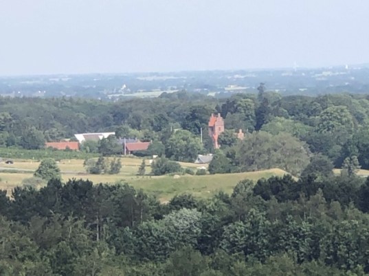
The Wooden Tower looks like a tornado from far away, as the steel structure supports a circular spiral wooden walkway from the base to the top. As you make your way round and round, on your way up from the forest, when you start to get above the treetop line, and then the 360 views kick in. You look down at the forest below, as well as some small villages and towns off in the distance. A steady wind was blowing at the top, but not to brisk to make it uncomfortable. I’m guessing it took 12-15 minutes to walk from the base to the top, as the walk was very gradual, not taxing at all. Maybe 16 circles in all (kinda like a slinky). I’d say 50 or so people were at the park while I was there. Once they put a bus stop closer by, attendance will increase exponentially.
woodTower2
Since the structure is wide open, each step up and down affords you different views, shadows, leaving your imagination to ponder all things wonderful and joyous! Kinda reminded me of the 1960’s TV show opening credits, where the camera angle took you through the spiral effect.
The builders of the Wooden Tower have taken great care to disrupt as little of the forest as possible, so the walkway meanders around trees, and in a few areas, is built right around the tree trunks. In the center of the Wooden Tower are very large 3 trees which were constructed around. These reach about 40-50% of the way up, and adds a softening effect while going round and round.
woodtower3
The Wooden Tower is about 45 meters high, which I’m told is the highest structure in the whole area. You’re supposed to able to see Sweden, far off in the distance. I stayed on the top level for 30-minutes or so, enjoying the views, the wind in my hair, the sunshine on my skin. So nice!
woodtower4
The only downside is that there is no direct public transportation, so you either need a vehicle, or walk the mile or so along the bicycle lane adjacent to the highway, from the closest bus stop. It’s another 3/4 of a mile along the trailway to the top of the Wooden Tower.

Saint Martin: a Day Trip

April 2019

img_20190401_093008A peaceful coexistence of two separate nationalities and cultures displayed on this island of St. Martin/Maarten was comforting. This island has been divided 60/40 between the French Republic and the Kingdom of the Netherlands since 1648, and roughly one half of the population of 78,000 live in each side.

Our cruise ship docked at the terminal in Philipsburg(population: 1,327) in the Dutch side. We joined a tour offered by the cruise ship since we had some ship credit to spend, and the tour bus drove us to Marigot(population: 5,700), the capital of the French side 11 Km northwest of the port after driving around the island. There is a public bus(mini vans) system that connects the two cities for $2, and one can flag the bus down any where around the island.

File:Saint martin map.png

There is no border between the two sides, and people move about freely. However, a phone call from one side to the other is an international call. The power sockets look different, and the official languages are English and Dutch in one side and French in the other. French side uses Euro, and the Dutch side has its own currency. U.S. dollars are accepted widely everywhere, though.

Marigot had the feel of a small European town with restaurants, bakeries and shops by the boat docks. We had 45 minutes to wonder around, and that was long enough to see what’s there to see.

img_20190401_111649

We stopped at a bakery called Carousal which had a free merry-go-round ride in the back. It seemed to be a popular tour bus stop, and a long line was formed around the gelato station. We were thirsty by this time, and we had to have it.

We got off the tour bus at the local shopping street when we returned to Philipsburg. It is basically a one street town, and jewelry shops and gift shops lined this street called Front Street.

File:PhillipsburgStMaarten.jpg

There was a nice beach lying parallel to Front Street, and we enjoyed this area much better than the shopping street. There were some bars and restaurants right on the beach where people were hanging out.

We were thinking of taking the boat shuttle back to the cruise dock, but nobody was around to tell us when this boat was running. After a few minutes of searching, we gave up and walked into a restaurant nearby. We had some chicken wings and beer to cool down before heading back to the cruise terminal. The walk was about 15 minutes and easier than we expected.

img_20190401_133011

Two places people often mentioned to check out on this island were: Club Orient Beach where clothing is optional, and Maho Beach, which is situated at the end of the airport’s runway, so landing large aircraft fly just feet over the beach. We did not go to either of them.

map-of-caribbean

St. Lucia: a Day Trip

April 2019

img_20190410_143457

St. Lucia sounded too much like Santa Lucia, an ocean side district in Naples, Italy, and I thought I would find a connection between the two.

As we pulled into the bay of the capital city Castries(population: 20,000), we could see a cityscape with nice looking hillside houses and some modern structures. I’ve noticed that the countries with population of over 100,000 people seemed to have a definite urban center, and this certainly was the case: St. Lucia has 190,000 people. The shopping area was rather cozy at the cruise terminal, and it did not pretend that there was free WiFi. The tourist information office had free maps. We declined offers of $25 tour around the island and went into town on our own.
Coming out of the terminal, we turned left toward the water and got the ticket for the ferry($5 r/t) that took 5 minutes to deposit us at the other dock in the city. A smaller cruise ship was docked at this pier. You had to go through an indoor air-conditioned shopping center to exit to the city. We turned left then right a few blocks later, and that was the center of the town where the city hall and the parliament building were located.
The Cathedral was a nice surprise: it was good sized and the interior was beautifully decorated with local design.
img_20190410_133824
img_20190410_133844img_20190410_133927
The day had started with a rain shower, and the rain kept coming back every time we thought it had finally stopped. We ran into the park across from the Cathedral and ducked under the gazebo to escape the rain when we came out of the church. There, local people were busy looking at the screen of their cell phones.
Oh? Can it be true? And, yes! Free working WiFi. Thanks to the Taiwanese government, the whole city was covered by this service – not always well, but we appreciated that it was there!
This park was named after a poet, Derek Walcott, a Nobel Literature Prize winner. Who knew there is a Nobel winner in a little place like this one! Turned out, another person from St. Lucia won a Nobel Prize: Dr. William Arthur Lewis in economics.
We walked back toward the direction of the water and came to the Central Market. It was good sized with stalls selling fruits, vegetables, fish, meat, clothing, and crafts.
Coming out from here, we turned left and walked 10 or so minutes to reach King’s Park. It was not a big park but had a bit of beautiful flowers and plants.
Heading back, we noticed the market actually spilled over to this area, and it was actually located right next to the fancy air-conditioned shopping center that we had to pass through earlier.
Through out this exploration, we did not see a single reference to St. Lucia, Italy. The streets were decorated with blue and yellow triangle flags in celebration of 40 years of independence from the British rule.
Before getting back on the ferry, I decided to take advantage of the free WiFi and do some search. The signal was not very reliable by the dockside, but I was able to find out that the name St. Lucia came from St. Lucy of Syracuse. Nothing to do with Italy.
img_20190410_131943-effects
We could have gone outside the city to see more natural beauty, but it was the 10th port we were visiting during this trip, and what one can see on an island seemed pretty much the same every where.
map-of-caribbean